


col du loup

franquen
User
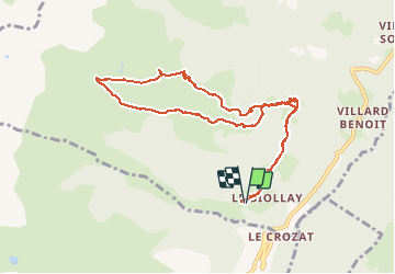

Length
10.2 km

Max alt
2066 m

Uphill gradient
797 m
Km-Effort
21 km

Min alt
1308 m

Downhill gradient
787 m
Boucle
Yes
Creation date :
2020-02-16 07:29:55.574
Updated on :
2020-02-16 15:29:57.11
5h38
Difficulty : Easy

FREE GPS app for hiking
 SityTrail
IGN / Geographical institutes
SityTrail Plus
The world is yours!
About
Trail Touring skiing of 10.2 km to be discovered at Auvergne-Rhône-Alpes, Savoy, La Léchère. This trail is proposed by franquen.
Positioning
Country:
France
Region :
Auvergne-Rhône-Alpes
Department/Province :
Savoy
Municipality :
La Léchère
Location:
Bonneval
Start:(Dec)
Start:(UTM)
299058 ; 5041569 (32T) N.
Comments